Island Formation

|
HISTORY: Island Formation |
|
It's easy to think that things that are... always have been. But that's not the case. Whether we look at individuals, families, communities, or countries, we know that they change and certain things in their history have affected how they are now. The same is true with land masses on our planet... even barrier islands. As much as we love to experience the beauty and life in and around the islands, it is only right that we take the time to learn what it is that makes them so special. I hope you find it as fascinating as I did to learn some of the influences that have formed the Georgia Barrier Islands.
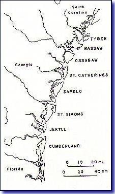
There are eight groups of islands that make up the Georgia coast, from Tybee down to Cumberland. [Take a look at this map.] Each group contains two sets of islands that were formed during different geologic time periods. One set was formed 35,000 to 40,000 years ago (Pleistocene islands), while the newer set was formed just 4,000 to 5,000 years ago (Holocene islands). But here's an amazing fact: All total, seven sets of barrier islands have been identified from 40 miles inland to the present set of barrier islands. The 5 interior sets have been incorporated with the main land. The last two sets are still islands.
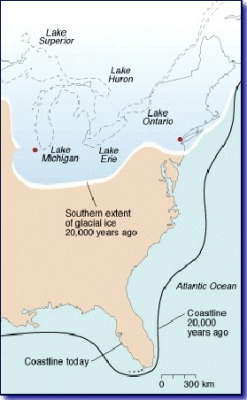
Over time, the reach of the ocean has fluctuated over 100 miles, from the Okefenokee Swamp to the outer edge of the continental shelf, then back again to its present location, due to various climatic changes. It may surprise you to know that whale bones have been found in the region between Macon and Savannah, from the time when it was underwater. Later, about 20,000 years ago (during the Wisconsin ice age), the coast was at least 50 miles east of where it is now - out where the continental shelf is. As the earth warmed and the ice melted, the coast began to recede. New Holocene barrier islands were formed, and some were pushed onto their Pleistocene ancestors. So what we have now is the eight groups of islands that are a mixture of overlapping geologic periods. In some cases, the islands are distinctly from one period. (Sapelo is Pleistocene, while Blackbeard, Cabretta Beach, and Nannygoat Beach are Holocene). Other islands, such as Jekyll, Cumberland, and St. Catherines, were formed during two separate geologic periods.
It may also surprise you to learn that the oceans are rising at the rate of 6 inches per century. If the global warming theory is correct, this century will see an 18 inch rise, pushing the coast back by an average of two miles. I wouldn't invest in beach front property, if you intend to hold on to it for very long!
Island formation is a dynamic process that is still occurring today. The forces that create and modify coastal barrier islands include: the topography of the ocean floor, tides, waves, wind, and man. Georgia's coastline is the most western portion of the Atlantic Coast. It sits in the large South Atlantic Bight (meaning, a bend or curve in the shoreline). Because of this, tides which rush in and out twice a day are funneled inward, piling up the water to much greater heights than the rest of the coastline. Tides on the sides of the funnel (FL and SC) are only 3 feet, but along Georgia's coast they reach 6 to 9 feet.
Unlike other states along the coast, Georgia is recessed 60-70 miles from the continental shelf and the gulf stream. This provides two very helpful benefits. It causes the wave crests to be smaller (shallow water dampens the energy of large waves) and provides some protection from hurricanes (since hurricanes tend to follow the warm air of the gulf stream).
But other forces are at work, changing the islands' shape. Barrier islands tend to be shaped like turkey legs - fat on the Northern side and slender on the southern side. Why? Sediment carried from rivers are pushed southward by the combined forces of tides, winds, and longshore currents. These deposits build at the north end of the barrier island, creating a wedge or "turkey-leg" shape.
But this is hardly a static process. During storms, breakers pull sand from the beach and dunes and deposit it on offshore shoals. After a while, these shoals build up enough that waves "trip" or break on them before reaching the beach. This action helps to suppress the further erosion of the beach. When storms subside and the energy of the waves dissipates, the waves gradually transport much of the shoal sand back to the beach where it is deposited in mounds. Winds, then dry the sand and blow it back onto the beach. This is called the "sand sharing system". While it provides some homeostasis (equilibrium), it does cause the shape of the beach to change over time.
Unfortunately for humans, we like the beach so much, that we want to build homes, hotels, and entire cities on them. What most people don't understand is that nature never intended them to stay in one place. They are going to change shape and to try to stop that process is going to require a concerted effort to dredge and reconstruct the beach, periodically. Which is exactly what the residents of Tybee (and other island communities) have been doing every few years.