Barrier Islands

|
HISTORY: Barrier Islands |
|
Barrier Islands have a characteristic topography (set of physical features) and ecology (relationship between organisms and their environment). Barrier Islands typically have 4 ecosystems: the ocean beach, the maritime forest, the freshwater sloughs, and the salt marsh.

The ocean floor in front of Georgia's beaches is relatively shallow. This dampens the intensity of the waves. Smaller waves produce gentle sloping beaches in Georgia, with up to a quarter mile of exposed beach at low tide. The beaches tend to be wet and compact, with less dry-sand area. The grain of the sand here, is also finer than in other coastal states, where strong waves push in the coarse sand from offshore. Georgia's relatively weaker wave system also results in fewer shells being pushed onshore.
The intertidal zone of the beach is a graveyard. Here is where all sorts of dead or dying things wash up and are trapped as the tide recedes. A good place for shell collecting, the intertidal zone is also the hiding spot for a number of critters that burrow into the sand - ghost crabs, ghost shrimp, plychaete worms, etc. Those that don't make it, become food for crabs, birds, raccoons, rats and insects.
The beach moves from the intertidal graveyard to a desert of loose, shifting sand on the upper beach, where hardly anything grows. It then continues upward to the primary dune where some hardy vegetation begins to take hold. This vegetation must be able to withstand the sandblasting effect of salt spray and wind swept sand. Sea oats, yucca, prickly-pear cactus, sandspurs, beach croton are common inhabitants. Sea oats are the most successful competitor in this environment and are protected by law because of their vital role in building and stabilizing the dunes.
Further up the beach, the interdune meadow is characterized by flowering weeds, grasses, and woody plants. Water and nutrient retention is still a problem in this area as winds desiccate the vegetation and blow away the decayed material. A gradual migration toward the maritime forest requires the existence of the shrub forest - pine, wax myrtle, red cedar, and various oaks are cloaked with various vines. Animal life (birds, deer, snakes, rabbits, raccoons) find shelter in the shrub forest, as well. It is estimated that it takes a century or more to build an oak maritime forest from a beach.
The Maritime ForestThe maritime forest is the culmination of the quest for life in the harsh barrier island environment. The canopy and understory of trees and shrubs provides shelter and nesting sites for various birds, squirels, snakes, and tree frogs. The larger trees include: live oaks, southern magnolias, pines, and cabbage palms. The shrubs and smaller trees include: red bay, yaupon holly, American holly, sparkleberry, cherry laurel, and wax myrtle.
Besides shelter and nesting opportunities, the great value of the canopy is moisture retention. The humid environment of the forest fosters plant growth and amplifies the rate of decomposition. Thus, nutrients are quickly returned to the root system, before the ever threatening winds can blow them away.
Live oak forest are considered true climax forests because of their ability to regenerate themselves. Pines, on the other hand, while more resistant to fire (particularly loblolly and slash pines), are unable to succeed themselves since they are unable to grow in the shade of their parent tree. Pines, however, are seen on many of the older islands (Sapelo, Jekyll, and St. Simons) where a great deal of clear cutting was done for cotton plantations.
A slough (pronounced, slou) is a muddy swamp or a temporary pond. Most are just low areas with sufficient clay sediments to collect rainwater. Sometimes they are formed by the oxbow of a tidal creek, where the flow of saltwater is halted. The dried up creek bed then becomes a holding tank for fresh water. Whatever their formation, freshwater sloughs are a vital part of the barrier island. These holding tanks provide freshwater during long periods of drought for various wildlife living on the island. They are also a favorite spot for alligators, who avoid saltwater and congregate on many of Georgia's barrier islands.
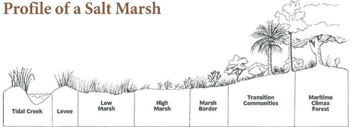
The Salt MarshBetween the barrier island and the mainland (or the older Pliestocene islands) lies the salt marsh. They follow the existing rivers well into the mainland. Due to the massive flooding of our high tides, some Georgia marshes are 4 to 8 miles wide. Georgia has one half million acres of salt marsh, or one third the amount of the entire east coast states. The salt marsh is also a hostile environment for many types of vegetation. Varying levels of salinity, flooding, and rapidly changing water temperatures eliminate most competitors. The clear winner for this niche is a unique grass called Spartina alterniflora (or smooth cordgrass). It accounts for 95 % of the marsh vegetation.
Moving from the harsh environment of the marsh, back toward the maritime forest, a similar transition occurs. A high point occurs which marks the highest normal range for tidal encroachment, and freshwater vegetation begin to take hold. Rains and runoff dilute the salinity to acceptable levels for various flowers, shrubs and small trees to thrive. This vegetation then joins with the maritime forest to complete the barrier island spectrum of life.